


|
|
|
|
|
|
|
Heidi at Columbia River Gorge 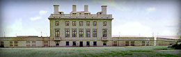
Maryhill Museum of Art 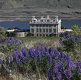
Lupines above Maryhill Museum of Art 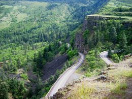
Below Tom McCall Nature Reserve 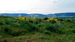
Wildflowers, Tom McCall Nature Reserve 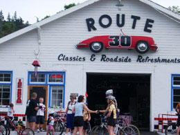
Route 30 ice cream & Porsches, Mosier 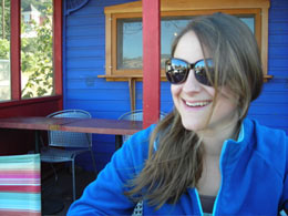
Leslie at 10-Speed Cafe, Mosier 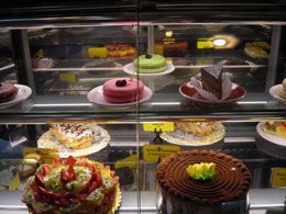
Petite Provence, The Dalles 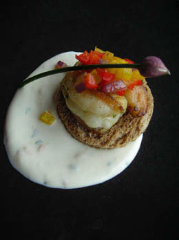
Amuse Bouche, Skamania Lodge |
Columbia River Gorge Scenic Area MAP Route: (Oregon side) Historic Columbia River Highway from Troutdale to Multnomah Falls / I-84 to Mosier / Hwy. 30 to Rowena / I-84 to Biggs Junction cross river return west via Washington State Route 14 (SR14) to Lyle [Spur route: From Lyle SR 142 up Klickitat River to Glenwood / Trout Lake return Hwy. 141 to BZ Corner / Husum / White Salmon] White Salmon / back on SR 14 Bingen / Carson / Stevenson / re-cross river at the Bridge of the Gods / I-84 return to Troutdale. Leisurely segments make this an adventure. Get out and explore waterfalls, great restaurants, wildflowers, ancient petroglyphs, whitewater and wineries.
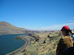
Day One: Troutdale to Hood River/Mosier Waterfalls, Windsurfing, Wine Hold on to your hats! Once off the bluff from Corbett and the first breathtaking view at Chanticleer Point and the Women’s Forum State Park scenic overlook, you’re finally on the historic highway twisting down to the restored Crown Point Vista House where you might join wind-whipped visitors battling the winds on the bluff. But oh! The view. This segment of the Historic Columbia River Highway to Multnomah Falls is less than 20 miles, but is purported to have the greatest concentration of high waterfalls in the continental United States. Roadhouses once dotted the old highway offering hearty meals, rooms and auto repair. Alas, there are only a couple left — View Point Inn and Bridal Veil Lodge. From Crown Point the road switchbacks into a lush forested canopy of maple, alder and cottonwood. Some waterfalls are visible from your vehicle, but get out for better views. Beware of helpful young guys who may show you how you can see more falls – a leap from the bridge to a vertical wall of moss and crumbling basalt and a scramble up. I do not recommend this, no matter how charming young guys may be. Do hike down the rocky sometimes-muddy trail to see Bridal Veil Falls. Take a peek across the road from the parking lot at the former roadhouse Bridal Veil Lodge Bed & Breakfast www.bridalveillodge.com. Beyond Bridal Veil, Wahkeena Falls is a lovely woodsy hike that’s often crowded. Don’t be surprised if you’re overtaken by serious walking-stick wielding Germans or get stuck behind a gaggle of text-messaging teens. Multnomah Falls, the largest and most famous of the waterfalls, cascades 620 feet down the sheer cliffs will be crowded too, but you expect it here. Hike up to Simon Benson Bridge, which crosses between the upper and lower cataracts and wave to friends or strangers below while you revive (or freeze) in the cool mists. Continue to Hidden, Dutchman, and Wiesendanger falls, or retreat to the 1925 historic lodge for coffee or a meal (no overnight accommodations here). Past Multnomah Falls drive onto the dam at Bonneville Lock and Dam & Bonneville Fish Hatchery (exit 40) where you can see locks in operation if you’re lucky and check out the Visitor Center fish-viewing windows. In spring and fall salmon (some referred to as hogs at 40-50 lbs) glide by nose to nose. At the hatchery see more salmon and get a glimpse of what prehistoric fish looked like as descendants, divinely huge and ugly sturgeon, lumber in their pond. For fun, toss food pellets (25 cents a handful) into an upper pond and make trout leap in a feeding frenzy. Cascade Locks (exit 44) is the berth of the sightseeing Columbia Gorge Sternwheeler www.sternwheeler.com and the entrance to the Bridge of the Gods, the site of tribal myth and geographic certainty that the two sides of the gorge were once linked. [see PLAY] At Hood River kite boarders and wind surfers glide careening, wind-driven and seemingly mad — a flurry of darting color. They propel their sailboards across the currents and gusty whitecaps fortifying Hood River’s claim as the wind surfing capitol of the world. Hood River’s waterfront park has good views, but you can stay out of the wind at Big Horse Brew Pub or Full Sail Brewing Company overlooking the river show. Big Horse is a steep-stepped climb, but has better views. So many restaurants, you may want to stay here a week. (See EAT.) Here, the cool lush forests give way to the semi-arid desert, where orchards and vineyards flourish. (For more about the Hood River area, including the “Fruit Loop” and Mt. Hood Railroad excursions, see Mt. Hood Loop.)
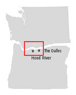
Day Two: Mosier to Lyle Porsches, A Library, Wildflowers and Wine The hiking-biking-bird watching Twin Tunnels Trail connects Mosier with Hood River via a closed portion of the historic Columbia River Highway leading through a mixed confer forest, oak woodlands, and grasslands. More trails wind through wetlands at Waterfront Park. Forget I-84 and take Oregon Hwy. 30 out of Mosier for a glorious meandering drive six miles through cherry orchards and oak dotted uplands to the high basalt bluffs of the spectacular Tom McCall Preserve www.nature.org. February through June wildflowers! Late summer and autumn this plateau on the easternmost segment of the Historic Columbia River Highway seems a bit brownish and bleak but worth the view. Great hikes too, but it’s a Preserve, so no dogs. Before you drive on, take a look over the edge at the series of hairpin-curves you’ll soon be descending. Fair Warning: pay attention to winter weather forecasts. The Dalles derived from French “dalle” describes the flagstone-like basalt outcroppings that once comprised a series of rapids, now underwater after the construction of Bonneville and The Dalles dams. Once a major tribal fishing and trading community, the site was among the longest continuous human habitation in North America. With the arrival of fur traders and seamen in the 1800s and pioneers in the 1840s, “white man’s” diseases and banishment to reservations eradicated thousands of years of a thriving civilization. The Dalles was the abrupt end of the overland Oregon Trail, leaving pioneers to pay for passage through the treacherous Columbia River rapids. For natural history, Native American cultures, the Lewis and Clark expedition, the Oregon Trail, and great views, check out the Columbia Gorge Discovery Center / Wasco County Historical Museum www.gorgediscovery.org. More cowboy country than new-age wind surfing and wine touring Hood River, The Dalles does have the oldest bookstore in Oregon, Klindt’s Booksellers, at nearly 135 years. The city has a fine collection of 19th and early 20th Century homes and buildings, including the 1856 Ft. Dalles Surgeon’s Quarters, the 1864 U.S. Mint (now home to Erin Glenn Wines) and the 1876 Baldwin Saloon with its authentic bar and wall-to-wall collection of turn-of-the-20th century barroom nudes and western landscape oil paintings. Need new cowboy boots or a Stetson? Tony’s Town & Country Clothing. Lodging here? A few unremarkable B&Bs and chain motel, but promises of more to come with riverside development thanks to the arrival of Google. [ARCHIVES: Fishing the Deschutes and On the Bus]
Day Three: Lyle to Stevenson Fresh Fruit, Hot Springs, Petroglyphs, and Yes, Wine Near Biggs Junction, there are signs designating Celilo Park and Celilo Indian Village. You will see little — a few homes, a wayside pullout — mere place markers for Celilo Falls, once one of the most significant fisheries on the Columbia River. My mother gave us children the directive: “See this and remember.” I can’t help but remember. Those awesome thundering rapids, tribal men wielding long-poled dip nets leaning skillfully from suspended, rickety wooden scaffolding above the roiling water. Salmon leaping, that deafening roar, children playing, women sitting on woven blankets watching, weaving baskets, playing cards. In March 1957, backwater from the newly constructed The Dalles Dam began to rise. In less than a week, more than ten thousand years of tradition drowned. At Biggs Junction head across the bridge to Washington State (US 97) and take an immediate right to Maryhill State Park with shade trees, lawns and an easily accessible swimming beach (with rest rooms for clothes changing), an oasis for hot summer days when you’ve been in the car a little too long. Parallel to the park a side road (Peach Beach RV access) is lined with summer fruit and produce stands — Walla Walla onions, peaches, potatoes, ripe tomatoes — all fresh from nearby farmers. On the top of the hill (US 97) to the right, is the facsimile Stone Henge and to the left (west) on Washington State Route 14 (SR 14) is Maryhill Museum, another childhood wonder — a castle-like chateau on the barren plateau high above the Columbia River. The bizarre collections still mesmerize including giant chess sets, the nearly three-foot tall Paris haute couture fashion mannequins in stage sets, Queen Marie of Romania’s bejeweled coronation gown and crown, gilt furniture, Faberge doodads, European paintings, and Russian Orthodox icons. These days tall poplars and cottonwood trees shade lush lawns, still an anomaly amid the spare desert landscape. Walking toward the grand stone-staired entrance, peacock cries and a hot breeze remind me of childhood visits where fascination was tempered by the heat, wind and those haunting peacock calls. The permanent collection of old rotates with a fine collection of Lewis and Clark memorabilia and Native American art and artifacts. Café Maryhill (open March 15-Novemver15) has sandwiches (local smoked salmon) and drinks that you can take outdoors to the patio for the spectacular view. Good food, blue skies, bright sun and the breathtaking panorama cannot quell that old childhood sense. It still feels lonesome. SR 14 is slower going than I-84 in Oregon, but views from the high bluffs are breathtaking. A short hop from Maryhill Museum is Maryhill Winery www.maryhillwinery.com. This mid-section of the gorge is rich in Pacific Northwest history, most notably the extensive Native American cultures and the Lewis & Clark expedition. The area is the gateway to Mt. St. Helens and Mt. Adams and the region on both sides, hidden in the hills and plateaus of the gorge, has sprouted so many vineyards it has recently been designated as a new wine appellation — Columbia Valley www.winesnw.com Fair warning: Many wineries are by appointment only. Not to be missed a few miles east of Lyle is Columbia Hills / Horse Thief Lake State Park www.parks.wa.gov where ancient petroglyphs can be seen. My grandfather Cody and uncles logged these hills — Goldendale to White Salmon and had a sawmill at Lyle. The mill is now gone, replaced by lovely grasses and trees — a short walk over the railroad tracks from the Lyle Hotel. [ARCHIVES: She Who Watches, Say Uncle, The Fox, Oh Boy, and Trains!] Optional: add a day Spur Loop Trip (SR 142/141 approx. 125 miles) At Lyle, a loop drive along the Klickitat River north on SR 142 follows the rush of white water spilling through rugged basalt and takes you up the canyon to the lovely meadowlands of Glenwood Valley and eventually Trout Lake at the base of Mt. Adams. The river is frothy palest green, dizzying in its speed as it tumbles through the severe cuts. Watch for tribal fishermen on their rickety, cantilevered platforms netting for steelhead and Chinook salmon. At Husum there’s golf and barbecued pulled pork sandwiches at Hooba’s. The road climbs and soon narrows into almost one-lane blacktop. Naturally, this is at the steepest hairpin-curving ascent where you are eye to eye with eagles. The river is but a thread meandering below and the basalt canyons and oak trees have transitioned into the high Goldendale plateau of wheat fields and pine. Heading west toward Glenwood is the Conboy National Wildlife Refuge, the only nesting area in the state for greater sand hill cranes. The large prairie marsh amid pine and fir also harbors herds of elk and spring and fall migrations of Tundra swan, geese and ducks. Near Glenwood is the Flying L Ranch with its great view of Mt. Adams. Next up, Trout Lake, which has long been filled in with vegetation, but find snacks and maybe lunch here. [ARCHIVES: Trout Lake Afternoon] There’s golf and excellent food [Hooba’s] at Husum, white water rafting and horseback riding at Northwestern Lakes Riding Stables [ARCHIVES: Pepsi the Wonder Horse] on the way to White Salmon. White Salmon to Stevenson It’s a good night’s sleep, a hearty European-style smorgasbord
including fresh baked organic rye bread at Inn of the
White Salmon then down the hill to Bingen where if I hadn’t just eaten, I
would stop at the Solstice Café, since I love their salads, panninis,
handcrafted wood-fired pizzas and local wines. Bonneville pool, soak and home… [ARCHIVES: At Skamania Lodge] back to Columbia River Gorge overview
|
©2009-2010, MJ Cody, all rights reserved. Contact mj@sleeparoundnw.com |